
Due to the fact that when I told people I was leaving I got several monetary gifts from family and friends and awesome tips from customers I’d like to show that your money went to productive things so I’m dubbing some of you sponsors for excursions I may not have otherwise been able to afford.
For my inaugural sponsored entry, a huge thank you to Deb and Matt! I hope you think this is a productive spend…although I’m pretty sure you’d probably still approve if I took it to a bar, miss you guys!
After a night with the Maori and a bottle of Czech moonshine, it was off to Taupo, one of the bigger cities on the North Island. I use the term “city” very loosely as most of the towns had 0-1 stoplights and 1 gas station. En route, once again it was Hayden to the rescue as he had recommended for us to go to “Hot & Cold” a spring between Rotorua and Taupo that’s where a natural hot and cold stream met. Feels awesome it’s like going from the sauna to the pool without the inconvenience of having to step outside. But don’t put your face in the water or you could get a bacteria lodged in your nose that causes some kind of meningitis and death. Don’t say I didn’t warn you.
When we got to Taupo Urban Retreat we checked in, signed up for dinner which was chili and a beer for $7.50 (gotta start that backpacking budget) and headed out for a sushi lunch (ok, maybe I’m not so good at budgeting). And for the record, sushi in NZ sucks. Everything is pre-made and sits in a case and you pay per piece. I miss fresh sushi. After that we headed back to the hostel where Mark & Cely signed up to do a sailboat trip around the harbor and after some convincing by the hostel manager, I signed up for the Tongariro Crossing hike.
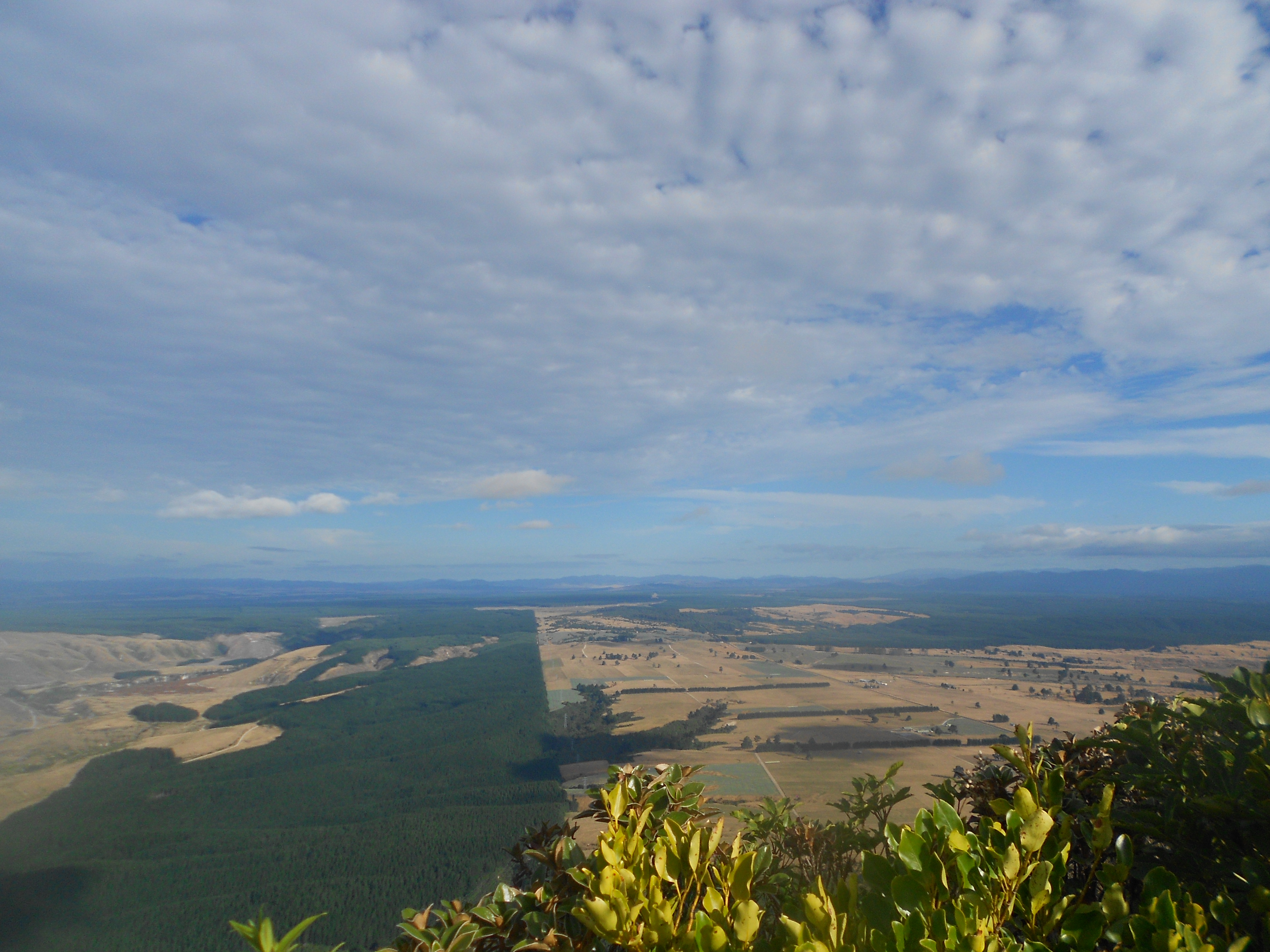
Having nothing to do for the afternoon, we asked the clerk what she recommended doing to kill a few hours and she said there was a nice easy 2 hour hike on a nearby mountain. Now when I hear 2 hour hike, I think in American terms. Two hours for the average person, quicker if you’re not fat and lazy. The hike was 2 hours for the average person…if the average person is a kiwi. It was on a dirt path through the woods and your average fat American would not have fit in some places on the path. There was also some minimal climbing and loose gravel – which made me glad I didn’t wear flip flips. Who wears flip flops to hike you ask? Fuck you I’m from New York. Fortunately we were able to make it to the top and the views were spectacular. Unfortunately, I didn’t know how doing this hike today would affect my 24k (15 mile) hike tomorrow.

When I got up the next morning after having not slept since I didn’t have an iPhone – which meant I had no clock, and no alarm so I kept waking up every hour to check Mark’s analog watch which I couldn’t really see in the dark, because I had no iPhone to illuminate it…it was 5 am, and while thankfully there were no roosters crowing a la Tahiti, the sun wasn’t shining either. A group of us headed out from the hostel and I immediately started talking to a English chick who told me she was doing the long route instead of the highlights trail. Seeing as she was the only person I had spoken to at that point, I said, sure I’ll do the same thing. Because being a sheep is always a good idea. Especially when you’ve already established that English people are crazy. By the time we got to the park, there were about 50 people on the bus and everyone started the hike in the same direction. There were quite a few people with intense hiking gear – poles, boots, camel packs, windbreakers, backpacks, and then there was us. This English chick, a Dutch guy, a dude from Cali and I teamed up and started walking together. It was cold as balls and we were all minimally packed. We were given a map, told the hike was 24 kilometers and told we better reach the other end by 5 o’clock when the last bus would be leaving. If we took longer than that or had to be rescued it would be at our own expense. Good luck guys!
The first part of the hike was fairly easy although quite cold, and then we reached the steps. The steps were basically what the map described as 40-60 minutes of climbing “The Devil’s Staircase”. Nick (the English chick)had taken the lead and was storming up the path. Not wanting to be left behind, or embarrass myself since I was the most novice hiker in our group, I chased her up trying to stay on her heels. Runner mentality much? The guys trailed behind us and as Jason would later tell us, it wasn’t much easier for them but they weren’t about to be shown up by a set of girls. Ah, masculinity.


By the time we reached the highest point of the trail we were all winded and broke out our expert hiker snacks that we had packed. I had a package of soy/seaweed crackers, someone else brought Pringles, and another British dude behind us rolled and smoked a cigarette. Ballin.


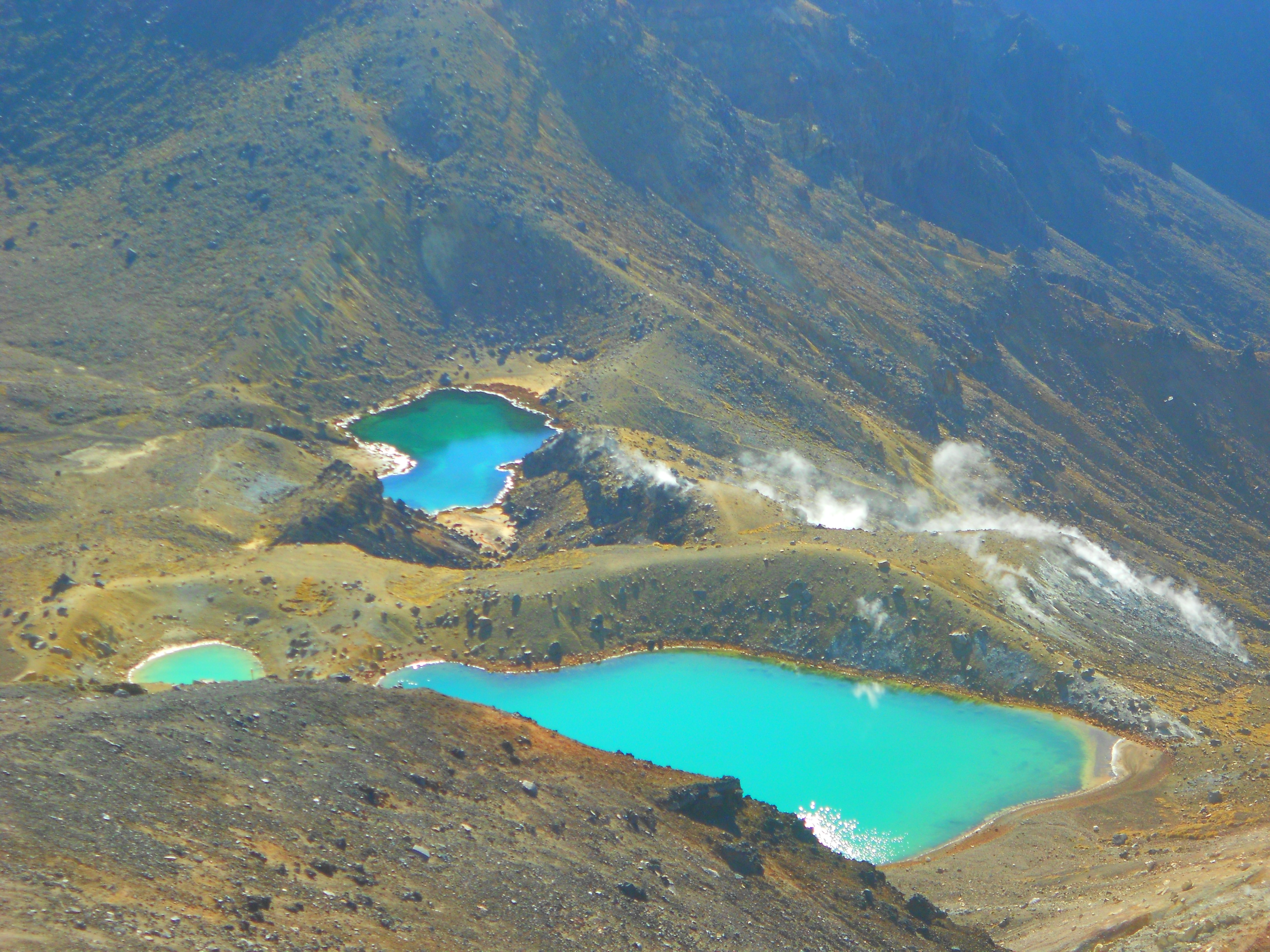
While the high point was awesome, we also got rather confused as to where the trail went since the only direction was down what appeared to be a mountain of sand and rocks loosely sitting on top of each other. The second I tried my foot on it I slid down on my ass. We were somehow the only people trying to go this way – which was apparently where the path split for the full trail vs the highlights trail. In for a penny, in for a pound, the 4 of us slid our way down the hill towards the gorgeous Emerald Lakes ahead of us. Notably, we also had to try not to fall off the narrow path into a crater/volcano or run off the edge into the lake. The guide describes this part as being of “moderate” difficulty. Moderate difficulty my ass.

After that, the hike got easier, easier being a relative term. Relative to sliding down an entire mountain with no footholds, trying not to scrape my ass since I had no appropriate hiking gear – walking down the rest of the volcano’s curvy, barely blazed trails with loose footing was a piece of cake – and another 7 hours long. During which there were was no luxury hiking – meaning no garbage cans, no food stops, no rangers, no cars and only 2 stops where you could wash your hands/use the bathroom (water was not potable, you had to bring your own).
I also realized that my knees were none too happy about the path, especially since what goes up must come down, and going down is really hard on the knees. That’s what she said.
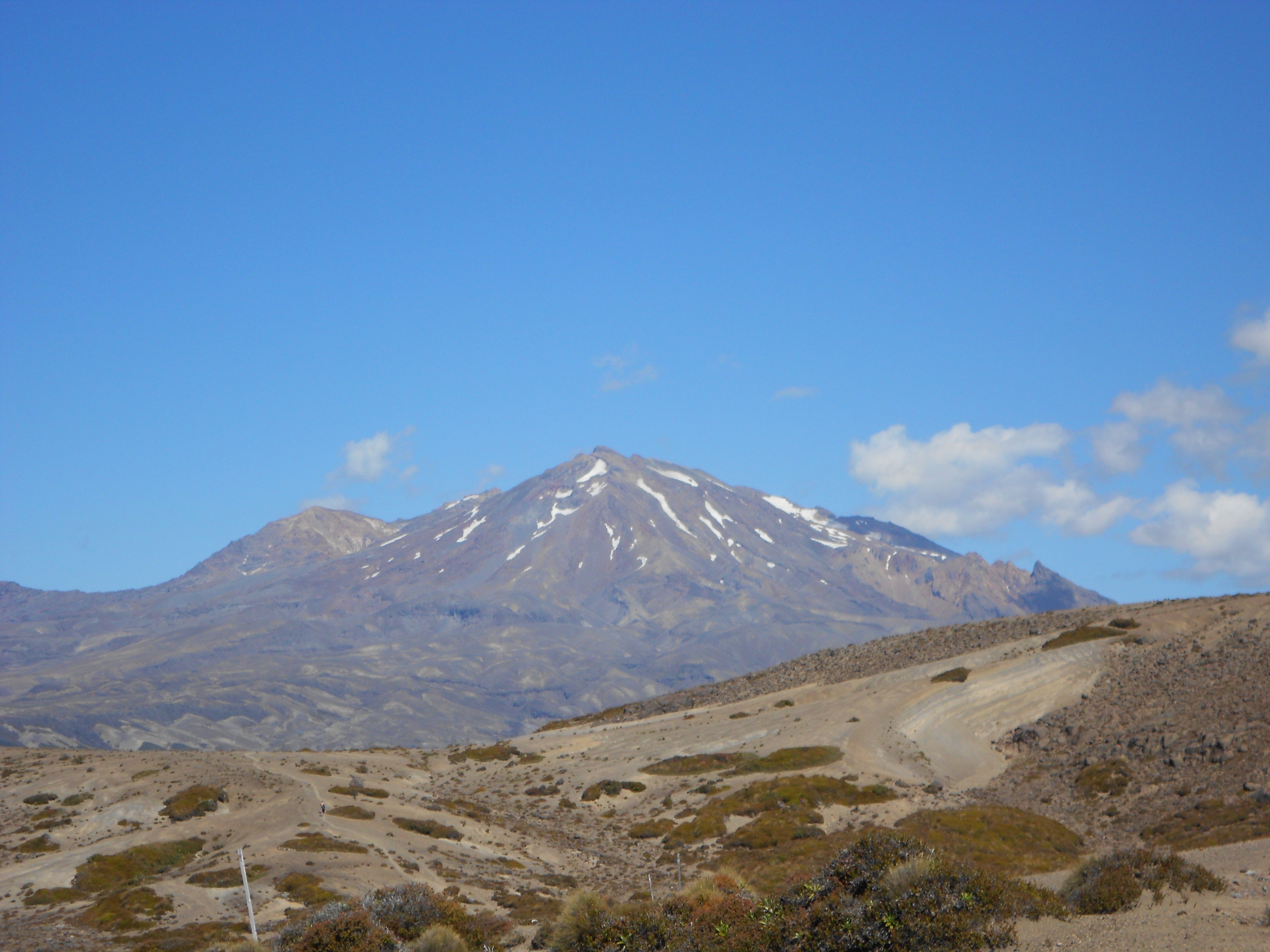

The trail was beautiful, but all the dust fucked my camera so a lot of my pictures started coming out blurry. Lacking photographic evidence and using my words…there were a shit ton of different volcanic landscapes and it felt like being on the moon at points. There was no wildlife and in the middle of the hike there weren’t even birds anywhere in the sky. Which I guess is better than having ominous vultures hovering over us as we trekked through the desert terrains. The hike ended up taking us about 8.5 hours – during which the conversation turned to what we wanted to eat when we got back (steak or Korean tacos) and how much we wanted a beer. When we reached the end I was actually super proud of myself for finishing since this was probably the most physically taxing thing I’ve ever done after the NYC Marathon – which I also did not train for. Proud of myself and hobbling to the bus with my blistered foot, as soon as I sat down the tour guide offered me a beer. Kiwis are awesome.

Tongariro Alpine Crossing Site
And in case your interested in the details of the hike, which was recently revised because of the eruption of the volcano, here’s the new Tongariro crossing information.
Mangatepopo to the Desert Road (west –> east)
9-10 hours/~24 kilometers
1) Mangatepopo to Soda Springs (1 hour)
Easy incline with solid terrain. aka cold and boring when you start at 6 in the morning
2) Soda Springs to South Crater (1 hour)
This is a steep section with a lot of steps. This is your first big climb for the day. This would be the part where we booked it up the stairs, feel the burn!
3) South Crater to Lower Red Crater Ridge (10 minutes)
This is an easy flat walk through the crater floor. Yup.
4) Lower Red Crater Ridge to the Red Crater Summit (30 minutes)
This is your second big climb for the day. Caution: steep with loose scree section from halfway up. After passing the scree section there is an easier climb to the summit of the track at the Red Crater. I didn’t know what “scree” was. In case you don’t either, it’s loose rocks that make climbing with non-athletic sneakers a bad idea.
5) Red Crater Summit to the Emerald Lakes (15 minutes)
Caution: This is a steep scree section down to the lakes. When you get to the lower lake, turn right. I hope you like sliding down long hills towards sulfurous lakes.
6) Emerald Lakes to Oturere Hut (1 hour 3 minutes)
Follow the marker poles to the right behind the lower lake. Caution: there is a steep section with a mix of scree and rocky terrain. Make sure of your footing going down. Getting to the bottom of the steep section will take approximately 25 minutes. Once at the bottom the track flattens out until you reach the Oturere Hut. This would be where I made the “going down is hard on your knees” joke. But seriously… Oh and you can stop at the hut for lunch, but don’t count on potable water, though the water is cold and good for freshening up
7) Oturere Hut to Waihohonu Hut (3 hours)
This is a relatively easy section. There is a steep rocky ridge, solid under foot, to go down just past the hut. Once at the bottom, the track gently rolls for a while across barren plains. In this area some of the marker poles are not standing so be aware and keep looking for the next one. The last hour of this section enters the forest with a couple of ridges. This part takes forever. You feel like you’re dying crossing a desert and when you finally get to the shady reprieve of the forest, it’s all uphill. Enjoy! On the bright side, I think the water at this hut was drinkable. Or at least I hope it was.
8) Waihohonu Hut to the Desert Road (1 hour 3o minutes)
When reaching the hut, follow the sign pointing to Desert Road. This is a nice easy section and mainly flat. When you reach the road your vehicle will be waiting for you on the other side. At this point, an hour and half is a lot longer than you think it is.
9) Desert Road
Congratulations you did it! Just hope your bus driver also provides you with cold beer at the end.
